Most of us use road numbers without giving them much thought. The A1 goes north, the A4 heads west and the A6 is heads up to Carlisle. They can feel like arbitrary labels attached to roads by an unknown committee, but Britain’s road numbers contain a surprisingly elegant geographical code.
It starts with six roads from London
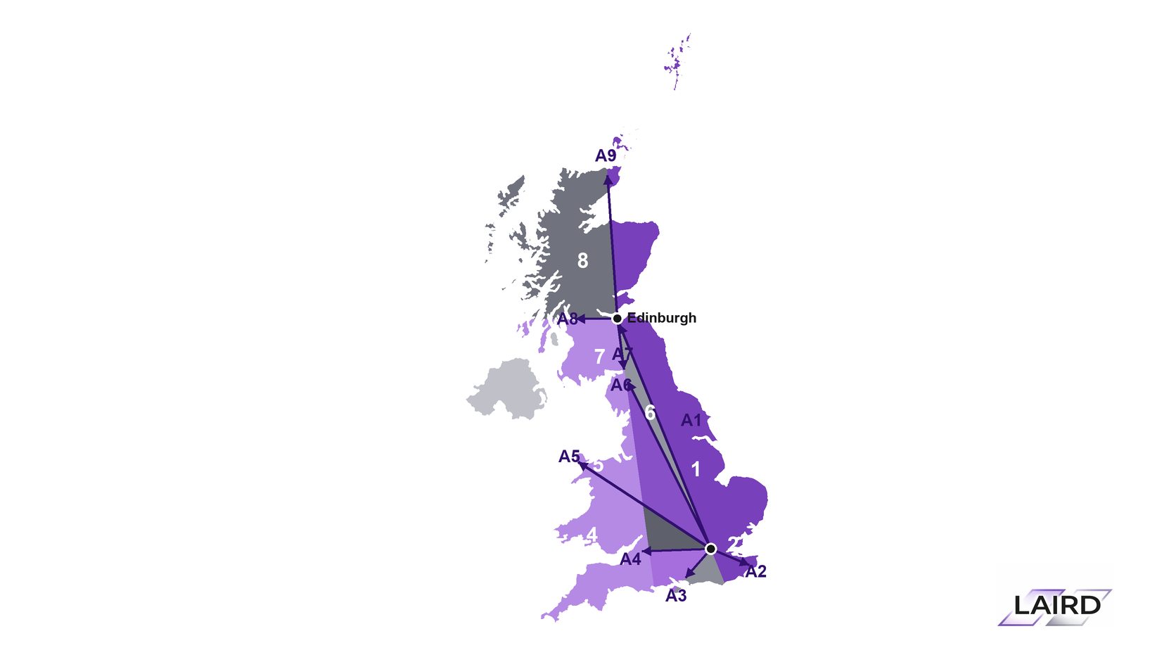
When A- and B-road numbering was introduced in 1921, England and Wales were divided into six large zones. Their boundaries were formed by six important roads radiating from London:
A1 — north towards Edinburgh
A2 — southeast towards Dover
A3 — southwest towards Portsmouth
A4 — west towards Bristol
A5 — northwest towards Holyhead
A6 — north through the Midlands towards Carlisle
These roads appear in clockwise order around London. The areas between them became zones numbered 1 to 6. This does not mean that “1” means north or “4” means west. The numbers identify sections of the country, not compass directions.
The first digit gives away the zone
The clever part is that smaller A-roads normally take the first digit of the zone in which they begin.
The A455, for example, starts with a 4 because it belongs to the zone between the A4 and A5. Its number quietly tells you that it is in the West Midlands side of the country.
The same pattern can be seen elsewhere:
Roads beginning with 1 generally originate east of the A1.
Roads beginning with 2 are generally found between the A2 and A3.
Roads beginning with 3 occupy the area between the A3 and A4.
Roads beginning with 4 begin between the A4 and A5.
Roads beginning with 5 begin between the A5 and A6.
Roads beginning with 6 occupy the remaining area between the A6 and A1.
The principle applies to both A- and B-roads, so an A455 and a B-road beginning with 4 both owe their first digit to the same geographical zone.
A road that crosses a zone boundary does not normally change its number. It usually keeps the number determined by where it began. The A38, for instance, starts in the 3-zone but continues far beyond it.
Scotland has its own Edinburgh-based pattern
The system changes when it reaches Scotland.
There, three more principal roads radiate from Edinburgh:
A7 — south towards Carlisle
A8 — west towards Glasgow and Greenock
A9 — north towards Perth, Inverness and Thurso
These create the 7, 8 and 9 zones. Roads beginning with those digits can therefore provide a useful clue that you are in Scotland.
The two systems meet around the Scottish Borders, with the A1 linking their London and Edinburgh hubs. Transport Scotland still describes road numbering in terms of these geographical zones. More here: Transport Scotland
What do the letters mean?
The letter indicates the road’s classification:
A-roads form the principal network linking towns, cities and other important destinations.
B-roads are classified routes of more local importance.
Unclassified roads make up much of the remaining local network and are not usually identified by a public route number.
A shorter number often belonged to a more significant road in the original system. An A-road with one or two digits was generally more important than one with three or four. A century of bypasses, extensions and reclassifications means that this hierarchy is no longer completely reliable.
There are exceptions
Britain’s road network has changed enormously since the numbering scheme was created. Roads have been rerouted, combined, shortened and renumbered, producing plenty of anomalies.
Motorways also have a related but separate zoning system in England and Wales, while Scottish motorways often take the number of the A-road they replaced. Northern Ireland uses a separate road-numbering scheme altogether. So the system is best treated as a geographical guide rather than an infallible rule.
A map hidden in plain sight
The next time you see an unfamiliar road number, look at its first digit. It may tell you roughly where in Britain the road began before you have even opened a map.
The A455 is not called that because it travels in a particular direction. The 4 places it within a slice of the country first mapped out more than a century ago.
Britain’s road signs have been displaying this hidden map ever since—and most of us have been driving past without realising it. The government dates the introduction of A- and B-road numbering to 1921, according to the Department for Transport